Clear Creek Metropark
185 Clear Creek Road
Rockbridge, OH 43149
 Clear Creek Metro Park (Columbus Ohio Metro Park) offers over 5200
acres of woodland interspersed with cliffs, ravines, rock formations and
creeks. There are four main picnic areas, fishing and hiking.
Clear Creek Metro Park (Columbus Ohio Metro Park) offers over 5200
acres of woodland interspersed with cliffs, ravines, rock formations and
creeks. There are four main picnic areas, fishing and hiking.
Centuries of glacial flooding have cut the valley through the Blackhand sandstone. Oak and hickory forests intermingle with giant hemlocks and ferns along with the last remaining Ohio colonies of rhododendron providing a wonderful place to hike and bird watch.
Click here for a birder's guide to Clear Creek:
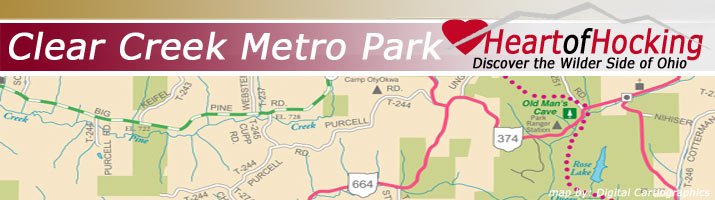
Directions to Park:
From I-270, take U.S. 33 east toward Lancaster about 31 miles.
From Lancaster, continu e on U.S. 33 south about seven miles to Clear
Creek Road (County Route 116–Sunoco gas station on the corner).Turn
right on Clear Creek Road. Picnic areas, facilities and trails are
located along Clear Creek Road for the next seven miles.
e on U.S. 33 south about seven miles to Clear
Creek Road (County Route 116–Sunoco gas station on the corner).Turn
right on Clear Creek Road. Picnic areas, facilities and trails are
located along Clear Creek Road for the next seven miles.
 Explore the Hocking Hills, but do so wisely. Stay on the trails! Find Hocking Hills Cabins. The information provided is correct to the best of our knowledge. All rights reserved. Prices, facilities and availability are subject to change at any time and may contain errors. Although the information given is updated, immediate changes may not be available. Please call the park, agency, cabin, camping area, private facility ahead for updated information before visiting. This organization may contain many outside contacts and has no control over the content of these sites. The park is open dawn to dusk -Please stay on the trails. These sites may be accessed by visitors to the site at their own discretion. Visit our Hocking Hills Cabins!